|
East Java is one of the
Republic of Indonesia's 35 provinces, occupying an area
of some 48,000 square kilometres just south of the equator.
Including the island of Madura, it accounts for a little
more than a third of Java's total land surface and supports
a population of almost 33,000,000 inhabitants. To the east,
across a narrow strait, lies the island of Bali; to the
west are the provinces of Central Java and the Special Region
of Yogyakarta.
THE LAND
 Anyone
who opens a physical map of Java will notice immediately
the high, mountainous ridge extending along the entire length
of the centre of the island. Some of the highest and most
active of these volcanic peaks are to be found in East Java,
whose flat, fertile plains are punctuated by no less than
six separate ranges, becoming progressively higher towards
the east. These mountains are among East Java's principal
attractions and some of the more outstanding include the
3,676 metre active cone of Mt Semeru, Java's highest peak;
the famous sand sea and steaming crater of Mt Bromo; the
sulphureous summit of Mt Welirang, and the strangely beautiful
crater lakes of Ijen and Kelud. Anyone
who opens a physical map of Java will notice immediately
the high, mountainous ridge extending along the entire length
of the centre of the island. Some of the highest and most
active of these volcanic peaks are to be found in East Java,
whose flat, fertile plains are punctuated by no less than
six separate ranges, becoming progressively higher towards
the east. These mountains are among East Java's principal
attractions and some of the more outstanding include the
3,676 metre active cone of Mt Semeru, Java's highest peak;
the famous sand sea and steaming crater of Mt Bromo; the
sulphureous summit of Mt Welirang, and the strangely beautiful
crater lakes of Ijen and Kelud.
 Two
main waterways, the Brantas and Solo rivers, are lifelines
for much of East Java's predominantly agricultural community.
The former rises in the highlands to the north west of Malang
and follows a circuitous path before dividing into a number
of smaller streams to meet the sea at Surabaya. The famous
Bengawan Solo, longest river in Java, has its source in
the centre of the island and stretches 540 kilometres before
joining the coast at Gresik. Other important rivers include
the Madiun, Konto, Sampeyan and Grindulu. Two
main waterways, the Brantas and Solo rivers, are lifelines
for much of East Java's predominantly agricultural community.
The former rises in the highlands to the north west of Malang
and follows a circuitous path before dividing into a number
of smaller streams to meet the sea at Surabaya. The famous
Bengawan Solo, longest river in Java, has its source in
the centre of the island and stretches 540 kilometres before
joining the coast at Gresik. Other important rivers include
the Madiun, Konto, Sampeyan and Grindulu.
THE CLIMATE
Like the landscape, East Java's climate is varied, depending
upon altitude. The plains and lower hill regions are hot
and humid, making conditions ideal for wet rice cultivation
(sawah). Further up in the hills the air becomes quite cool,
while in high mountainous areas at night the temperature
can drop to near zero. Hill regions are well suited for
the cultivation of a large variety of fruits and vegetables,
which thrive in the colder climate. Principal crops, aside
from rice, include corn, tobacco, sugar cane, coffee, rubber,
kapok, cloves, tea, cocoa, peanuts soybeans and cotton.
In addition, there are extensive plantations of teak and
pine. East Java has a marked wet and dry season, with rain
occurring between October and April. The wettest months
are December, January and February.
 GEOGRAPHY GEOGRAPHY
AREA : 47,921 sq. km. Capital : Surabaya. Borders: Java
Sea on the north, Indian Ocean on the south, Province of
Central Java on the west and Bali Strait on the east. Rivers:
There are 30 rivers. The five largest are among others :
Brantas, Bengawan Solo, Bedadung, Madiun and Baru. Mountains
: Semeru, Argopuro, Bromo, Anjasmoro, Arjuna, Mahameru,
Kelud and Merapi. Lakes: Sarangan and Karang Kates. Humidity
: 83%. Rainfall : Relatively low, on an average of 2,000
mm per year.
FLORA AND FAUNA
Flora : Teak, “kesambi”, pilang pinus, eucalyptus,
mahagony, bulbophyllum orchid, canarium vulgare (kenari),
“keben”, candlenut, quinine, sandalwood, “leban”,
”kenanga” (Canagaadorata), “rasamala”,
“sonokeling”. Fauna: Java tiger, Bawean tiger,
wild pig, wild cat, kancil (Tragulus pygmaeus), wild buffalo,
wild boar, wild fowl, grey monkeys, snake and frogs.
POPULATION
35,478,000 (2000). Density: 741 persons per sq. km (2000).
RELIGIOUS FOLLOWERS
Moslems (96.86%), Protestants (1.42%), Roman Catholics (0.91%),
Hindus (0.56%) and Buddhists (0.22%).
PRIMARY PRODUCTS
Agriculture – Food Crops : Rice, corn, peanut and soybean.
Commercial Crops :Coconut, clove, rubber, cacao, tea and
coffee. Livestock : Cows, horses, goats, sheep, pigs, rabbit,
chickens and ducks. Fishery – Fish Products : Tuna,
skipjack tuna, shrimp, anchovy, gouramy, common carp, milk
fish and tilapia. Forestry – Forest Products : Rattan,
resin, incense, log and ebony. Mining : Petroleum, LNG,
coal and tin.
PLACES OF INTEREST
Surabaya Zoo, Tretes and Selecta hill resort, Wendit and
Sarangan lakes, Ngliyep and Pasir Putih beaches, Trowulan
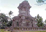
historical museum, temples of Penataran and Singasari, Ijen
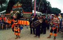
crater, Kesodo ceremony of the Tengger people on Mount Bromo,
Blauran hunting game park, bull racing (karapan sapi) on
Madura Island, Mount Bromo, Empu Tantular museum, Trinil
museum and Brawijaya museum.
|